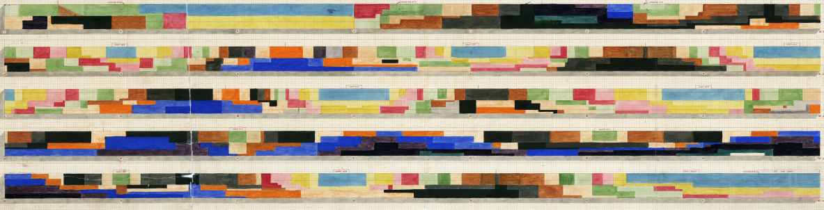
A detailed record drawing of the digging of Floriana tunnel helps understand how it was engineered. The original drawing uses a colour code to track the progress of digging every fortnight. It also includes the locations for three types of excavation: from shafts dug directly down, from ‘headings’ that were cut horizontally, and cut-and-cover.
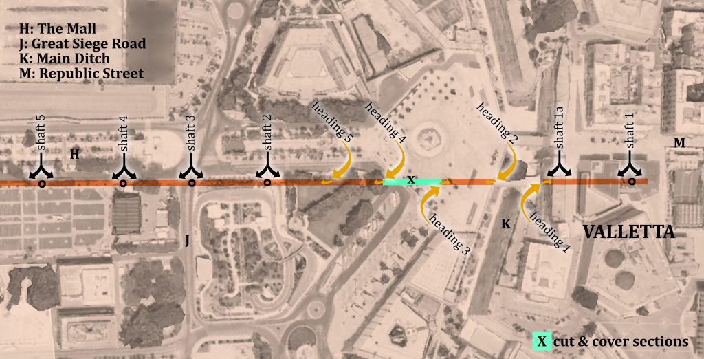
Cut and cover involves digging a trench, building a vaulted roof, and then burying the tunnel again. This is best used where the tunnel will be closest to the surface. There are two areas where this is recorded, one next to the main road into Valletta, and another in the ditch behind St Philip’s Bastion in Floriana.
Headings involve cutting the arched head of the tunnel first, driving it horizontally through the ground, then excavating the remaining waste down to the desired level.
Using shafts required digging directly down through the rock, then digging out horizontally in both directions once the desired depth is reached. This also requires the digging of the vault first. Unlike heading or cut-and-cover, all the waste has to be lifted vertically out of the narrow shaft.
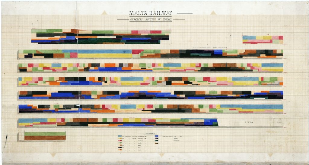
The historic drawing, now in The National Archives of Malta, specifies which of these techniques was used in which location. The attached diagrams interpret the locations at-scale on a modern aerial view.
One of the Victorian photographs recording the construction of the railway includes all three techniques in use. Taken from the curtain wall of Valletta, it shows the main railway tunnel portal cut directly into the Floriana side of the ditch. this was heading No.1.
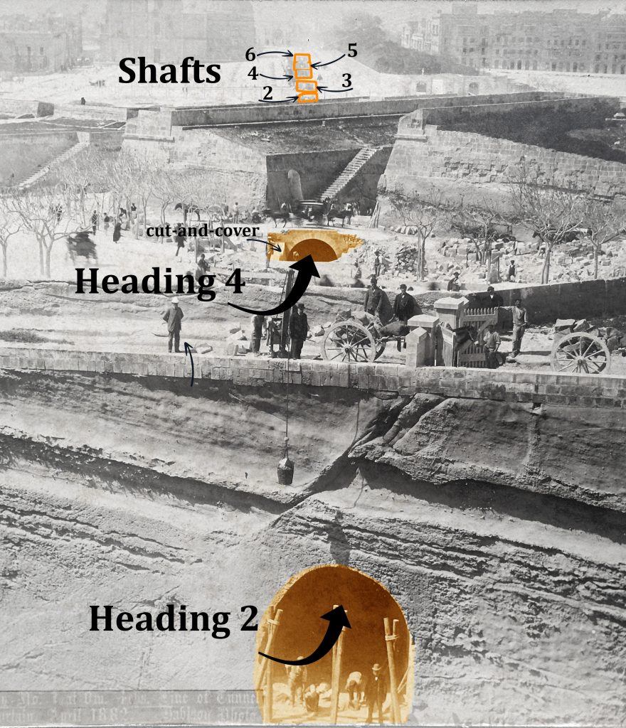
Above it can be seen another arch burrowing under traffic on the main road from Floriana. This is Heading No.4. Heading No.3 dug in the opposite direction and hidden from view, but between the two there’s an open trench dug that’s still waiting for the stone tunnel vault to be constructed before being re-buried.
Heading No.5 took advantage of a ditch between the two outworks shown here to continue direct excavation in the direction of Floriana.
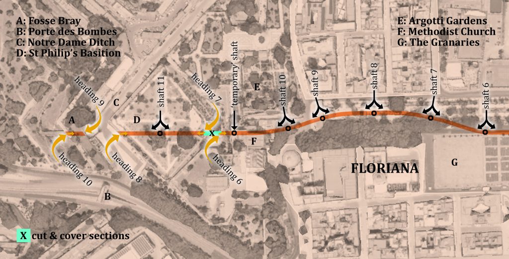
Beyond the outer defences of Valletta, the tunnel became deeper as it descended towards Floriana. Five of the vertically bored shafts can be identified edging the Granaries before the line of the tunnel had to curve northwards under The Mall gardens.
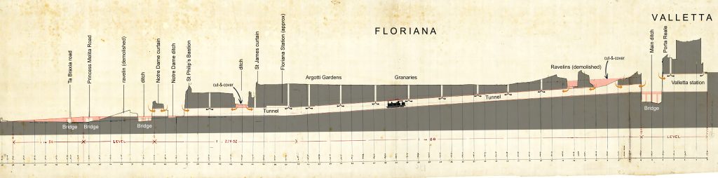
Strangely, there is no inclusion of excavation of the underground station at Floriana, though Shaft 10 can still be seen in the vault above the station platforms.
Also something of a mystery is the “temporary” shaft dug behind the Methodist Church. It’s very close to heading No.6 and the cut-and-cover section in St Philip’s ditch, so appears to duplicate those works. There’s contradictory drawings, but it may have been behind the tenaille and between it and St James’s Curtain. In this case it could have been removed entirely when this was later opened up to the sky. Looking at the timing diagram, it doesn’t appear to have had much effect on the digging. Was it an easier way of lifting waste out of the ditch?
This temporary shaft might still be there, but I didn’t notice it when I visited. Does anyone have any photos?

No responses yet